General Instrument Questions You Should Know Flashcards

1
Q

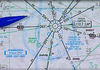
A series of T’s on this charts indicates what?

A

time zone boundaries

2
Q

What is the difference between the white and grey shaded areas?

A

ATC will provide IFR aircraft separation in the white areas (controlled airspace). Grey areas is class G airspace

2
Q

What is a STAR?

A

Standard terminal arrival route (STAR) provides a common method for departing the enroute structure and navigating to your destination. Star’s usually terminate with an instrument or visual approach procedure.

2
Q

What is Aeronautical Decision Making (ADM)?

A

A systematic approach to the mental process used by aircraft pilots to consistently determine the best course of action in response to a given set of circumstances.

3
Q

What do the green lines symbolize?

A

They are jet routes above 18,000 feet MSL which is normally for High Altitude Enroute Charts, but are included in the Low Charts for orientation and transition between the two charts.

3
Q

A route that brings traffic from different directions into one STAR is called a what?

A

Transition.

3
Q

What does D.E.C.I.D.E stand for in the decision-making process?

A

Detect the fact that a change has occurred

Estimate the need to counter or react to the change.

Choose a desirable outcome for the success of the flight

Identify actions which could successfully control the change

Do the necessary action to adapt to the change

Evaluate the effect of the action

4
Q

R-4806E indicated by the magenta diagonal lines means what?

A

restricted airspace

The identifier, affective altitudes, times of activity, and the controlling agency will be listed. (UNL/100 means 100 feet above ground to an unlimited ceiling).

4
Q

What is a TERP?

A

Terminal Instrument Procedures

4
Q

What are the five Hazardous Attitudes and the steps for the Antidotes?

A
  1. Anti-authority (“Don’t tell me!”)
  2. Impulsivity (“Do something quickly!”)
  3. Invulnerability (“It won’t happen to me!”)
  4. Macho (“I can do it!”).
  5. Resignation (“What’s the use?”)

Recognition of hazardous thoughts is the first step toward neutralizing them. After recognizing a thought as hazardous, the pilot should label it as hazardous, then state the corresponding antidote. The antidotes are:

  1. Anti-Authority - Follow the rules. They are usually right.
  2. Impulsivity - Not so fast. Think first.
  3. Invulnerability - It could happen to me.
  4. Macho or Ego - Taking chances is foolish
  5. Resignation - I’m not helpless. DECIDE!
5
Q

Where can you find information about a VOT?

A

You can find a VOT frequency for a particular airport in the

Airport Facility Directory or on the

A/G Voice Communication Panel of the FAA IFR Area chart or

IFR Enroute Low-Altitude Chart.

When checking your VOR using a VOT, the CDI should be centered and the OBS should indicate that the aircraft is on the 360 degree radial +/- 4

6
Q

When do you need a operable 4096 transponder?

A
  1. Within class A airspace
  2. Class B airspace
  3. Within 30 NM of class B primary airports
  4. In and above class C airspace
  5. Above 10,000 ft
  6. Mode C for IFR flight at all times unless ATC directs otherwise
7
Q

What is a D.P and a S.T.A.R and what are their differences?

A

An instrument departure procedure (DP) is a preplanned IFR procedure published in graphic or textual formats to provide pilots with obstruction clearance from the terminal area to the enroute structure. The two types of departure procedures are an Obstacle Departure Procedure (ODP) and a Standard Instrument Departure (SID)

Standard terminal arrival route (STAR) provides common method for departing the enroute structure and navigating to your destination. It is established to simplify clearance delivery procedures and usually terminates with an instrument or visual approach procedure.

8
Q

What is RNAV, RNP, and the parameters for RNP approaches?

A

Area navigation (RNAV) is a method of instrument flight rules (IFR) navigation that allows an aircraft to choose any course within a network of navigation beacons, rather than navigating directly to and from the beacons. This can conserve flight distance, reduce congestion, and allow flights into airports without beacons. Area navigation used to be called “random navigation”, and hence the acronym RNAV

Required navigation performance (RNP) is a type of performance-based navigation (PBN) that allows an aircraft to fly a specific path between two 3D-defined points in space. RNAV and RNP systems are fundamentally similar. The key difference between them is the requirement for on-board performance monitoring and alerting. A navigation specification that includes a requirement for on-board navigation performance monitoring and alerting is referred to as an RNP specification. One not having such a requirement is referred to as an RNAV specification.

RNP also refers to the level of performance required for a specific procedure or a specific block of airspace. An RNP of 10 means that a navigation system must be able to calculate its position to within a circle with a radius of 10 nautical miles. An RNP of 0.3 means the aircraft navigation system must be able to calculate its position to within a circle with a radius of 3 tenths of a nautical mile

9
Q

What are the holding patterns speeds?

A

6,000 ft and below - 200 kts

Below 14,000 ft - 230 kts

Above 14,000 ft - 265 kts

10
Q

What does the letter ‘A’ mean?

A

The approach course is not aligned within 30 degrees of the runway. A circle to land movement will be required to land the airplane.

11
Q

What is the maximum airspeed when conducting a procedure turn?

A

200 kts

12
Q

What is a ILS?

A

A instrument landing system (ILS) is a precision approach navigational aid which provides highly accurate course, glide slope, and distance guidance to a given runway

13
Q

What is a localizer?

A

A localizer transmitter provides information regarding your alignment with the runway centerline.

14
Q

How sensitive is the CDI needle on the VOR when using it for the localizer?

A

Each dot is .5 degrees.

2.5 total on either side

5 degrees total.

15
Q

What is a LDA?

A

A localizer type directional aid (LDA) is a type of localizer-based instrument approach to an airport. It is used in places where, due to terrain and other factors, the localizer antenna array is not aligned with the runway it serves. In these cases, the localizer antenna array may be offset (i.e. pointed or aimed) in such a way that the approach course it projects no longer lies along the extended runway centerline (which is the norm for non-offset and non-LDA localizer systems). If the angle of offset is three degrees or less, the facility is classified as an offset localizer. If the offset angle is greater than three degrees, the facility is classified as a localizer-type directional aid (LDA). As a “directional aid,” and only a Category I (CAT I) approach, rather than a full-fledged instrument landing system (ILS), the LDA is more commonly used to help the pilot safely reach a point near the runway environs, where he or she hopefully can see the runway, at which point he or she will proceed and land visually, as opposed to (for example) full Category III (CAT III) ILS systems that allow a pilot to fly, without visual references, right down to the runway surface or very close to it depending on the exact equipment in the aircraft and on the ground.

An LDA uses exactly the same equipment to create the course as a standard localizer used in ILS. An LDA approach also is designed with a normal course width, which is typically 3 to 6 degrees
.

16
Q

What is a SDF?

A

Simplified Directional Facility (SDF) is a localizer-based instrument non-precision approach to an airport, which provides final approach course similar to instrument landing system (ILS) and localizer type directional aid (LDA) approaches, although not as precise.

The SDF signal is fixed at either 6 or 12 degrees, as necessary to provide maximum flyability and optimum course quality. Unlike an ILS, an SDF does not provide vertical guidance in the form of a glideslope.The SDF course may or may not be aligned with the runway because its antenna may be offset from the runway centerline. Usable off-course indications are limited to 35 degrees either side of the course centerline
.

17
Q

What is approach speed category and how is it calculated?

A

Each aircraft is placed into an approach category based in its computed approach speed. Aircraft approach category means a grouping if aircraft based on a speed of VREF (reference landing speed), if specified, or if Vref is not specified, 1.3 x VSO. The 1.3 VSOapproach speed equals 130% of the aircraft’s power-off stall speed in the landing configuration at the maximum certified landing weight.

18
Q

IF the glide slope becomes inoperative during an ILS procedure, what minimums are used?

A

Localizer minimums.

19
When on the glide slope during a precision approach, the missed approach point is what?
Decision height
20
What are the standard alternate minimums for precision and non precision approaches?
Precision approaches - * 600 ft ceiling * 2 SM visibility Non Precision approaches - * 800 ft ceiling * 2 SM visibility
21
What is a MDA?
**The minimum descent altitude (MDA)** is the _lowest altitude (in feet MSL) to which descent_ is authorized on final approach, or during circle-to-land maneuvering _in execution of a non-precision approach_. Unlike a DH, a missed approach need not be initiated immediately upon reaching the altitude; that decision can be made at any time before reaching the missed approach point (MAP). A pilot flying a non-precision approach may descend to the MDA and maintain it until reaching the MAP, then initiate a missed approach if the required visual reference was not obtained. An aircraft must not descend below the MDA until visual reference is obtained, which differs slightly from a DH in that while the missed approach procedure must be initiated at or prior to the DH, because of its vertical momentum, during a precision approach an aircraft may end up descending slightly below the DH during the course of the missed approach. If a runway has both precision and non-precision approaches defined, the MDA of the non-precision approach is almost always greater than the DH of the precision approach, due to the lack of vertical guidance of the non-precision approach: the actual difference will also depend on the accuracy of the navaid upon which the approach is based, with ADF approaches and SRAs tending to have the highest MDAs.
22
When may you execute a straight -in-landing if the IAP has only circling minimums?
If you have the runway in sight Sufficient time to make a normal approach for landing And you have been cleared to land.
23
What is the difference between a visual approach and a contact approach?
A visual approach * **can be initiated by ATC or you can request the approach.** * Minimum 1,000 ft ceiling AGL with 3 SM vis * must have airport or preceeding aircraft in sight * remain clear of clouds A contact approach * **ATC cannot initiate a contact approach** * 1 SM ground vis
24
WHat is the difference between distress and urgency?
Pilots in **distress** are threatened by serious and/or imminent danger and require immediate assistance. **"MAYDAY, MAYDAY"** An **urgency** situation requires prompt assistance to avoid a potentially catastrophic event **"PAN, PAN"**
25
If you lose IFR radio communications, what route do you follow?
1. Assigned 2. Vector 3. Expected 4. Filed
26
If you lose IFR radio communications, what altitude do you follow?
**M.E.A** MEA Expected Assigned (last) always choose the _HIGHEST_ of the three
27
When may a surveillance approach be used?
At airports for wwhich civil radar instrument approach minimums have been published
28
During no-gyro approaches, what type of turns are used?
Prior to being handed off to the final approach - * **All turns standard rate** After being handed off to the final approach - * **All turns half standard rate**.
29
What is Hypoxia and its different types?
When the tissue is NOT getting enough oxygen. 1. Hypoxic hypoxia - when accending too quickly in altitude (Can't get O2) 2. Hypemic Hypoxia - the blood can't carry oxygen (Can't carry O2) Ex: Anemia 3. Stagnant Hypoxia - Poor circulation of oxygen (Can't circulate O2) 4. Histoxic Hypoxia - cells don't accept oxygen (Can't use O2) Ex: Alchohol, drugs.
30
What does the cross mean?
The point where you begin the decent at the glide slope for the final approach.
31
What does the dashed line represent?
A decent from 'GUUDE" to the missed approach point for a for a **localizer only approach.**
32
What do these points represent?
Step down fixes for the nonprecision approach.
33
What does the 'M' stand for?
The missed approach point for the nonprecision approach.
34
What does this section mean?
The missed approach point for a precision approach. This is also known as the decision altitude (DA)
35
What does the bottom row of numbers represent?
The distance from the landing threshold.
36
What do these top row of numbers represent?
The NM distance between fixes.
37
What does the 'V' stand for?
The visual decend point. The point where you may continue your decent beyond the decision altitude (DA) id you have the runway in sight.
38
What is this section called?
Conversion table section.
39
What would this bottom line be used for?
For nonprecision approaches, it is the time it would normally take, based on groundspeed, to reach the missed approach point (MAP) from the final approach fix.
40
What does MALSR stand for?
Medium Intensity Approach Lighting System
41
What does this mean?
The configuration of lighting is unknown
42
Whata is this section called?
Landing minimums
43
What does this mean?
Aircraft category based on aircraft approach airspeed. Category E is only for military aircrafts. The calculation is 1.3 X VSO at maximum landing weight.
44
What does 'FULL' mean?
The landing minimums when all components are operational
45
What does 'RVR 18 or 1/2' mean?
A Runway Visual Range of 1,800 feet is needed to land. If RVR is not reported, a visibility of 1/2 SM is needed.
46
What does this section mean?
The requirements to land when when more than 1 component is inoperative.
47
What is this section for?
Requirements for nonprecision approaches.
48
If this is presented on a approach chart, what would it mean?
Sidestep landing minimums which typically is higher than other minimums. This allows you to fly an approach for one runway, then land on a parallel runway.
49
What does it mean when the straight in landing minimums is blank?
The final approach is not aligned within 30 degrees of the runway or if an excessinve rate of decent over 400 ft per NM is required between the FAP and the MAP.
50
What does NACO mean?
National Aeronautical Charting Office. (Government approach charts)
51
What does the 'T' stand for?
The airport has either non-standard takeoff minimums, or a published IFR departure procedure.
52
What does MSA HS 25 NM mean?
Minumum safe altitude is 3,100 feet 25 NM around the navaid. In this example, the navaid is the 'MARBE' LOM.
53
Again, what is this?
A feeder route to help you fly from the enroute structure to the approach.
54
What does this section mean?
The altitude Course Distance
55
56
At or above 18,000 feet MSL, where will you now be operating at and what does the FAR require you to do?
You will now be operating at Flight Levels, and the FAR's require you to set your altimeter to 29.92.
57
A specified route designated for channeling the flow of traffic as necessary for the provision of air traffic services is called what?
Air traffic service (ATS) route.
58
Indicated by green diagonal lines?
Warning, Alert or M.O.A airspace
58
Indicated by a series of C's. The lower left corner shows the upper limit of the airspace to be 4,500 feet MSL.
What is Class C airspace?
58
Indicated by a grey dashed lines in the low altitude enroute charts?
area charts
58
Indicated in the parenthesis and by the blue dashed line?
Class D and Class E airspace Asterisk symbol means hours of operations found on back panel entitled \*Part-time Terminal Airspace hours (Class C,D,E).
58
Small green circles with cogs?
civil VFR airports
58
Smooth green circles?
military VFR airports
58
Small blue circles with cogs?
civil IFR airports
58
Smooth blue circles?
military IFR airports
58
Anchors and the letter 'H' in the circles?
seaports and heliports
58
Indicated by capital letters and blue in color.
Which airports have standard instrument approach procedures?
58
.
What is the ICAO identifier?
58
What is the airport elevation?
58
Translated to 6,000
What is the longest runway length?
58
Indicated by lower case lettering and green in color.
Which airports are without published instrument approaches?
58
Indicated by the lower case 's'.
Which airports have soft surfaces?
58
Indicated by compass with line pointing to magnetic north.
What are Jeppesen VOR symbols?
58
Indicated by a serrated circle.
What are Jeppesen symbols for TACAN and DME facilities?
58
Indicated by a serrated circle within a compass.
What are Jeppesen VORTAC and VOR/DME symbols?
58
Indicated by the three rowed dotted green circles.
What are Jeppesen's NDB symbols?
58
Indicated by the half shaded pointed arrow.
What is the ILS Localizer symbol?
58
Indicated by being written in a box.
Which Jeppesen Navaids are part of an airway?
58
Indicated by the letter D.
What shows if the Monroe VORTAC has DME capability?
58
Indicated by (L) meaning low altitude.
What is the Monroe VORTAC operational range?
58
Indicated by an unboxed navaid.
Which Jeppesen navaids are NOT part of an airway?
58
What is the total mileage of V178?
58
Where are the total mileage between intersections and VORs?
58
On a typical 8NM wide airway, what happen when the change over point (COP) is not located in the middle of an airway that's longer than 100NM?
The airway extends horizontally 4.5 degrees from the naviad until it reaches the COP. This will happen anytime one side is longer than 51 NM.
58
Inicates a point on the airway where the course changes direction and where no intersection is designated. This area should NOT be used as a reporting point for ATC or when filing a flight plan.
What is a mileage break point?
58
These are checkpoints along an airway that provide a means for you and ATC to check the progress of your flight. They are often located at points where the airway turns or where you need a positive means of establishing you position. These areas are given five-letter names, and their actual location may be based on two VOR radials, DME, or other navaids. Arrows are placed next to the area pointing from the navaids that formed it.
What are intersections?
58
What is indicated by the long thin arrow?
The radial that defined the fix is not designated as a flyable route.
58
In a nonradar enviroment, you are required to make a position report when you pass over this point. If co-located with a navaid, the black triangle is placed inside of a compass.
What are compulsory reporting points?
58
Identified by open triangles where position reports are not required unless requested by ATC.
WHat are Noncompulsory reporting points.
58
• Guarantees obstacle clearance o 1,000 foot obstacle clearance over non mountainous terrain. o 2,000 foot clearance over mountainous terrain. • Lowest altitude to expect adequate navigational signal reception • Two-way communications NOT Guaranteed.
What is the minimum enroute altitude (MEA).
58
What does the symbol mean?
Possiable gap in navigational signal even if the MEA is maintained.
58
What does this symbol mean?
It indicates a change in the MEA. This symbol can also be used to indicate a change in MAA or to show a change in the MOCA when an MEA is not published for the route.
58
What does the symbol mean?
Minimum crossing altitude (MCA). This symbol is used only on FAA charts. It means that you must begin climbing *prior* to reaching the fix in order to arrive *over* the fix at the MCA.
58
What does the symbol mean?
That a MCA will occur at the Navaid. Information regarding the MCA is located elsewhere.
58
What does T mean?
A **minimum obstruction clearance altitude (MOCA)** is shown for some route segments. On Jeppesen charts, it is identified by the letter T (terrain) following the altitude. On FAA charts, an asterisk precedes the altitude. The major difference between an MEA and a MOCA is that the MOCA ensures a reliable navigation signal only within 22 nautical miles of the facility; conversely, the MEA ordinarily provides reliable navigation signals throughout the entire segment. ATC will only issue the MOCA as an assigned altitude when you are close enough to the navaid.
58
What does MAA stand for and it's purpose?
Occasionally, it is necessary to establish a maximum authorized altitude (MAA) for a route segment. At higher altitudes, you might be able to receive two or more VOR stations simultaneously on the same frequency, making the signals unreliable for navigation. MAA is the highest altitude you can fly based on the line-of-sight transmitting distance of VOR or VORTAC stations using the same frequency. It guarantees that you will only receive one signal at a time on a given frequency.
58
What is a MRA?
Minimum reception altitude (MRA) is the lowest altitude that ensures adequate reception of the navigation signals formaing the intersection or other fix. Operating below an MRA does not mean you will be unable to maintain the airway centerline, only that you may not be able to identify a particular fix or intersection. FAA charts alerts you to an MRA by enclosing the letter R in a flag.
58
According to the AIM, what reports should you make with ATC while in radar contact?
MARVELOUS VFR 500 Missed approach Approach fix inbound Radio failure Vacating assigned altitude Entering hold Leaving holding fix Other information (related to safety of flight) Unforcast weather Speed error (5% or 10 knots) Vfr on top altitude change Fix or position report Revised ETA (error greater than 3 minutes) 500- unable to climb or descend at 500 fpm
58
Standard turns in a holding pattern is to what side?
Right side
58
What is the time limit of the inbound leg in a holding pattern?
1 minute below 14,000. 1 1/2 minute above 14,000 feet. The entire pattern (below 14,000) should be 4 minutes in length.
58
What do you do if you have a strong headwind which makes your inbound leg longer that 1 minute?
What do you do if you have a strong headwind which makes your inbound leg longer that 1 minute? Decrease the time length of the outbound leg. Conversely, if the inbound leg is shorter than 1 minute, the outbound leg needs to be longer that 1 minute. All corrections are done on the outbound leg so that the inbound leg is on course and for 1 minute.
58
What do you do if you are adjusting for a crosswind while on the inbound leg?
The adjustment for the outbound leg needs to be 3xs the amount of the inbound leg. All corrections are done on the outbound leg so that the inbound leg is on course and for 1 minute.
58
What are the max airspeeds for holding patterns?
58
How many different sectors are there in a holding course?
Three - 180 degrees, 110 degrees, and 70 degrees.
58
A standard holding pattern entry from the 180 degree sector is called what?
Direct entry
58
A standard holding pattern entry from within the 110 degree sector is called what?
Parallel Entry.
58
A standard entry from the 70 degree holding pattern sector is called what?
Teardrop Entry
58
What does the third digit of the index numbers mean?
Identifies the filing order of the same navigational type.
58
What is this section of the heading called?
Communications section
58
What is this section of the heading called?
Briefing section
58
What does this box indicate?
Primary navigation aid used for the approach
58
What does this box indicate?
For a precision approach, this would be the height at the glide slope outer marker (OM) position. For a nonprecision approaches, this would be the minimum altitude at the final approach fix (FAF).
58
What information is located in this box?
This section will contain: 1. D**ecision altitude height DA (H)** - the height where you must choose to continue the approach or execute a missed approach during a precision approach procedure. or 2. **Minimum decent altitude height MDA (H)** - the lowest altitude to which you can descend on a nonprecision approach until you identify the runway environment or execute a missed approach.
58
What is this section?
Minimum Safe Altitude - provides 1,000 feet of obstruction clearance within 25 NM of the indicated facility unless some other distance is specified.
58
What is this section of the approach chart called?
Plan view - an overhead presentation of the entire approach procedure.
58
What is this?
Primary navigation aid information. This will always be shadowed and bolded. (Jeppesen)
58
What does the 'D' mean?
The facility transmit DME.
58
What does the 'H' mean?
A high altitude VOR station.
58
What does the 'T' mean?
The station is a terminal class facility.
58
What does the 'L' mean?
A Low altitude class VOR
58
This approach allows you to decend safely by reference to instrument instruments from enroute altitude to a point near the runway at your destination from which a landingmay be made visually. What is this called?
Instrument approach procedure (IAP)
58
This approach procedure is an instrument approach based on navigation system that provides course and glide path deviation meeting precision standards of ICAO. The Instrument landing system (ILS) and the GPS landing system (GLS) procedures are examples of this. WHat is this approach called?
Precision Approach (PA).
58
This instrument approach is based on a navigation system that is not required to meet the precision approach standards of ICAO Annex 10 but provides course and glide path deviation information. Baro-VNAV (vertical navigation), LDA with glide path, LNAV/VNAV (lateral navigation/vertical navigation) and LPV (lateral precision with vertical guidance criteria) are examples of this. What is this approach called?
Approach with vertical guidance (APV)
58
This approach procedure is an instrument approach based on a navigation system that provides course deviation information, but no glide path deviation information. VOR, NDB, and LNAV is an example of this. What is this approach called?
Nonprecision approach (NPA)
58
What are the different approach segments?
1. **Feeder routes** - approach transitions. Technically not considered an apprach segment but are integral to many instrument approaches. 2. **Initial approach fix (IAF**) 3. **Intermediate fix (IF)** 4. **Final approach fix (FAF)** - this section normally begins upon glide slope interception. At airports which incorporates VOR or NDB and an FAF is not designated, this is the point where the procedure turn intersects the final approach course inbound. This point is referred to as the **final approach point (FAP).** 5. **Missed approach point (MAP)** - For precision approaches, the MAP is when you have reached the decision altitude (DA).
58
The measurment from the touchdown zone elevation ot the threshold elevation of the runway served by the approach is called what?
Height above touchdown (HAT)
58
The measurement above the official airport elevation, which is the highest point of an airport's usuable runway is called what?
Height above airport (HAA)
58
The altitude at which you cross the runway threshold when established on the glide slope centerline is called what?
Threshold crossing height (TCH)
58
the highest elevation in the first 3,000 feet of the landing surface is called what?
Touchdown zone elevation (TDZE)
58
What is this section of the approach chart called?
Profile view
58
What would this point represent?
The beginning of the final approach fix at the glide intercept.
58
What does GS2235 represent?
The altitude you need to be at when passing 'GUUDE' on the glide slope.
58
What are the required equipments for IFR flight?
ATOMATOE FLAMES FLAPS + **GRABCARDD** ## Footnote Generator/Altinator Radio navigation Altimeter (pressure sensitive) Ball on turn coordinator Clock Artificial horizon Rate of turn on turn coordinator (quality of turn) Directional Gyro (heading indicator) DME (above 24,000 ft when using a VOR)
58
What are the fundamental skills for Instrument flight?
1st - Cross check (scanning) 2nd - Interpretation 3rd - Aircraft control
58
When does a IFR flight plan need to be filed before departure?
At least 30 minutes
58
What is the difference between bracketing, homing, and tracking?
ADF Tracking ## Footnote **Homing** to a station simply means pointing the aircraft in the direction of the station. The easiest way to do this is to turn the aircraft in the direction of the ADF needle until the needle points to the top of the indicator. With homing the crosswind pushes the aircraft away from the direct course and **the resulting path to the station will be curved.** **Bracketing** is selecting a heading while correcting for wind drift. The selected heading is based on wind angle **Tracking** is doubling drift to get back on course.