chapter 2 part 4 Flashcards
For practical (operational) analyses, thermal advection can be expressed as a function of three factors:
temperature gradient
height contour spacing
angle between isotherms and height contours
Temperature Gradient
It is determined by how close the isotherms are to
each other. Closely spaced isotherms increase the rate of thermal advection, especially if the wind is strong and blowing through the thermal gradient.
Height Contour Spacing
It determines the strength of the wind. Closely spaced height contours will lead to stronger winds and the potential for ahigher thermal advection
Angle between Isotherms and Height Contours
If the isotherms are perpendicular to height contours then the advection potential is higher.
Thus, thermal advection is maximized by the combination of:
- Closely spaced isotherms
- Closely spaced height contours
- Isotherms perpendicular to the height contours
show maximim thermal advection

Thermal advection is minimized by the combination of:
- Widely spaced isotherms
- Widely spaced height contours
- Isotherms parallel to height contours
show minimum thermal advection
The next stage is to determine
whether the advection is cold air or warm air advection.
cold air advection
If isotherms are approaching your point of interest that are colder than the temperature at your point of interest
warm air advection
If the isotherms are warmer
Estimation of Temperature Advection on Weather Maps
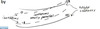
step 1
Sketch a streamline that intersects your forecast station. This is the line or curve along which the distances will be marked off. On synoptic charts a reasonable distance to evaluate the temperature gradient to estimate the advection is 100 km.
Estimation of Temperature Advection on Weather Maps
Step-1: Sketch a streamline that intersects your forecast station. This is the line or curve along which the distances will be marked off. On synoptic charts a reasonable distance to evaluate the temperature gradient to estimate the advection is 100 km
step2
Highlight the portion of streamline that intersects the station back 100km
Estimation of Temperature Advection on Weather Maps
Step-1: Sketch a streamline that intersects your forecast station. This is the line or curve along which the distances will be marked off. On synoptic charts a reasonable distance to evaluate the temperature gradient to estimate the advection is 100 km.
Step-2: Highlight the portion of streamline that intersects the station back 100km.
Step-3
Step-3: The temperature gradient is evaluated using central finite differences as:
ΔT/Δs = T2-T1 /DISTANCE
where T2 is the temperature furthest downwind on the segment and T1 is the temperature furthest upwind on the segment.
The temperatures are estimated by simply reading directly off of the isotherms.
Estimation of Temperature Advection on Weather Maps
Step-1: Sketch a streamline that intersects your forecast station. This is the line or curve along which the distances will be marked off. On synoptic charts a reasonable distance to evaluate the temperature gradient to estimate the advection is 100 km.
Step-2: Highlight the portion of streamline that intersects the station back 100km.
Step-3: The temperature gradient is evaluated using central finite differences as:
ΔT/Δs = T2-T1 /DISTANCE
where T2 is the temperature furthest downwind on the segment and T1 is the temperature furthest upwind on the segment.
The temperatures are estimated by simply reading directly off of the isotherms.
Step-4: The temperature gradient calculated in the last step is multiplied by the average wind speed on the segment.
Average wind speed is obtained by reading the wind barbs on the chart and taking an average value for the region of the segment of streamline.
