Part 6, Location-based computing Flashcards
what is geolocation
this is a location using longitude and latitude
Note:
this may not refer to your position but instead your internet connected devices position
what self identifying information does IBeacon transmit
this transmits
- UUID
- major
- minor
- Tx power
this becomes personal data when:
- It is used to identify you as an individual
- Tracking the location of a device to single out a single person
in which two cases does location data become personal data
in this use case of geofencing:
when the fence boundary is crossed by either entering or leaving then an action can occur
when implementing geofencing describe the use case of boundary crossing
this is a localisation process used for locating the geolocation of an object
describe the term
Geolocating
when IBeacon transmits this it could hold something like
the identifier of the individual beacon and so its location will be known
what information does the minor hold that Ibeacon transmits
describe
latitude
these are imaginary lines parallel to the equator
describe the term
Location based services
this is any service that relies on the location of the person to be useful. It will provide information based on the users current location
these use coordinates that are written in degrees
what are the values of the coordinates used in the latitude longitude system
This is the act of creating a virtual fence in which actions can take place when crossing or being inside or outside the fence
describe what geofencing is
these are two synonymous terms used to describe a device or service that is aware of its location and uses this information to provide services on this positional information
describe what the terms
Location based computing / location aware computing
refer to
this is data sent by the satellite and tells the receiver roughly where all other satellites are in orbit and which are most likely in its line of site
what is the
almanic data
sent by GPS satellites
these are imaginary lines parallel to the equator
describe
latitude
describe what geofencing is
This is the act of creating a virtual fence in which actions can take place when crossing or being inside or outside the fence
this transmits
- UUID
- major
- minor
- Tx power
what self identifying information does IBeacon transmit
what is the
Ephemeris data
sent by GPS satellites
this is data sent by the satellite and tells the receiver where it is in orbit
when the app receives a message from an IBeacon it will carry out an action such as speaking to a central database and then carrying out relevant actions based on whats in the database and what the app was programmed to do
what does the app listening for IBecaons do upon receiving a message
what is the
almanic data
sent by GPS satellites
this is data sent by the satellite and tells the receiver roughly where all other satellites are in orbit and which are most likely in its line of site
what is one protection that the data protection act 1998 provides
this states that if personal data is being collected about you then you must be informed about the data being collected and how it is processed as well as an option to opt out
this is a location using longitude and latitude
Note:
this may not refer to your position but instead your internet connected devices position
what is geolocation
- A satellite sends out a constant code
- The receiver has this same code running in sync with the satellite
- When the receiver compares the code it recieves with the code it is running it will see a time delay
- The time delay is used to find its distance from the satellite since radio waves travel at a constant speed and the position of the satellite is known
- When 3 distances from a satellite is known then its possible for the receiver to trilaterate its position
- A fourth satellite may be used for precision since it should meet the same points as all the others. If it does not then the receiver re syncs its own clock until all points meet
in 6 steps give an overview of how
GPS
works
describe the term
Geolocating
this is a localisation process used for locating the geolocation of an object
what two modes might geofencing be used in
this may be used in the following to modes:
1. boundary crossing
2. restrictions
what is trackR and tile and what do they both offer
these are both commercial services
what they offer
- they allow you to attach a bluetooth LE tag to an object.
- the tag then transmits its identifier
- an application will listen out for the tags transmissions
- when the app receives a transmission it will log the identifier and the location of the tag using GPS
what is trilateration
When applied to finding the location of a receiver this works by knowing your distance from 3 or more senders and then determining your location by finding the point where all the signals meet

this would not be classed as personal data if the data was aggregated with many other peoples data
such a situation would be if you were tracking a persons visit to different stores
when is the
Tracking the location of a device to single out a single person
not classed as personal data
describe what the terms
Location based computing / location aware computing
refer to
these are two synonymous terms used to describe a device or service that is aware of its location and uses this information to provide services on this positional information
this is any service that relies on the location of the person to be useful. It will provide information based on the users current location
describe the term
Location based services
what information does the Tx power hold that Ibeacon transmits
when IBeacon transmits this it is the
given power when you are a distance of 1 metre away. This will be hard coded upon install
while implementing geofencing describe the use case of placing
restrictions
when geofencing is used for this purpose:
restrictions could be put in place depending on whether you are inside or outside the fence
these are imaginary lines running in parallel from the north pole to the south pole
describe longitude
this is the point where the Greenwich meridian and equator cross,
it can be written as 0,0
in terms of longitude and latitude where is the
origin
and how is it written
what is a use case of trackR and tile
one use case of these commercial services would be:
to attach a tag to your keys. If anyone else was using the relevant application then you would be able to locate the last location of your keys
what information does the UUID hold that Ibeacon transmits
when IBeacon transmits this it could hold something like
a name brand such as coca cola
in terms of longitude and latitude where is the
origin
and how is it written
this is the point where the Greenwich meridian and equator cross,
it can be written as 0,0
when IBeacon transmits this it could hold something like
the name of the store that the beacon is in
what information does the major hold that Ibeacon transmits
in 6 steps give an overview of how
GPS
works
- A satellite sends out a constant code
- The receiver has this same code running in sync with the satellite
- When the receiver compares the code it recieves with the code it is running it will see a time delay
- The time delay is used to find its distance from the satellite since radio waves travel at a constant speed and the position of the satellite is known
- When 3 distances from a satellite is known then its possible for the receiver to trilaterate its position
- A fourth satellite may be used for precision since it should meet the same points as all the others. If it does not then the receiver re syncs its own clock until all points meet
when implementing geofencing describe the use case of boundary crossing
in this use case of geofencing:
when the fence boundary is crossed by either entering or leaving then an action can occur
Announced by apple in 2013 iBeacon is a protocol built for bluetooth low energy devices. Apps will listen out for iBeacons and act accordingly
what is
IBeacon
this states that if personal data is being collected about you then you must be informed about the data being collected and how it is processed as well as an option to opt out
what is one protection that the data protection act 1998 provides
what are the values of the coordinates used in the latitude longitude system
these use coordinates that are written in degrees
(degrees of the greenwich meridian line, degrees of the equator)
one use case of these commercial services would be:
to attach a tag to your keys. If anyone else was using the relevant application then you would be able to locate the last location of your keys
what is a use case of trackR and tile
describe longitude
these are imaginary lines running in parallel from the north pole to the south pole
this refers to the process of encoding a location into a human readable format such as ‘the shard’ from a geolocation
describe the term
Reverse geocoding
when IBeacon transmits this it is the
given power when you are a distance of 1 metre away. This will be hard coded upon install
what information does the Tx power hold that Ibeacon transmits
this may be used in the following to modes:
1. boundary crossing
2. restrictions
what two modes might geofencing be used in
when is the
Tracking the location of a device to single out a single person
not classed as personal data
this would not be classed as personal data if the data was aggregated with many other peoples data
such a situation would be if you were tracking a persons visit to different stores
describe the term localisation
this is a term used to describe the process used in which a location is found
some examples might be
- using GPS
- using WiFi
- using cell towers / base stations
- using bluetooth beacons
describe the term
Reverse geocoding
this refers to the process of encoding a location into a human readable format such as ‘the shard’ from a geolocation
in which two cases does location data become personal data
this becomes personal data when:
- It is used to identify you as an individual
- Tracking the location of a device to single out a single person
this refers to encoding a location from information such as an address into a geolocation
describe the term
Geocoding
when geofencing is used for this purpose:
restrictions could be put in place depending on whether you are inside or outside the fence
while implementing geofencing describe the use case of placing
restrictions
what is
IBeacon
Announced by apple in 2013 iBeacon is a protocol built for bluetooth low energy devices. Apps will listen out for iBeacons and act accordingly
describe the term
Geocoding
this refers to encoding a location from information such as an address into a geolocation
what information does the minor hold that Ibeacon transmits
when IBeacon transmits this it could hold something like
the identifier of the individual beacon and so its location will be known
what information does the major hold that Ibeacon transmits
when IBeacon transmits this it could hold something like
the name of the store that the beacon is in
what does the app listening for IBecaons do upon receiving a message
when the app receives a message from an IBeacon it will carry out an action such as speaking to a central database and then carrying out relevant actions based on whats in the database and what the app was programmed to do
this is data sent by the satellite and tells the receiver where it is in orbit
what is the
Ephemeris data
sent by GPS satellites
when IBeacon transmits this it could hold something like
a name brand such as coca cola
what information does the UUID hold that Ibeacon transmits
these are both commercial services
what they offer
- they allow you to attach a bluetooth LE tag to an object.
- the tag then transmits its identifier
- an application will listen out for the tags transmissions
- when the app receives a transmission it will log the identifier and the location of the tag using GPS
what is trackR and tile and what do they both offer
this is a term used to describe the process used in which a location is found
some examples might be
- using GPS
- using WiFi
- using cell towers / base stations
- using bluetooth beacons
describe the term localisation
When applied to finding the location of a receiver this works by knowing your distance from 3 or more senders and then determining your location by finding the point where all the signals meet
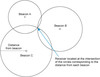
what is trilateration
describe the difference between trilateration and triangulation
- trilateration is used to find your position using distances from known objects
- triangulation is used to find your your position using angles (bearings) from known objects
