061.03 Charts Flashcards
Symbol 6 in the attachment is a(n) (…).

Symbol 6 in the attachment is a(n) (non-compulsory reporting point).

A large scale covers a (large/small) area in (good/bad) detail.
A large scale covers a (small)area in(good) detail.
Symbol 10 in the attachment is a(n) (…).

Symbol 10 in the attachment is a(n) (lighted obstacle).

Navaid 1 in the attachment is a(n) (…)

Navaid 1 in the attachment is a(n) (VOR/DME)

Symbol 15 in the attachment is a(n) (…).

Symbol 15 in the attachment is a(n) (aeronautical ground light).

Symbol 8 in the attachment is a(n) (…).

Symbol 8 in the attachment is a(n) (RNAV waypoint).

A small scale covers a (large/small) area in (good/bad) detail.
A small scale covers a (large) area in (bad) detail.
Symbol 9 in the attachment is a(n) (…).

Symbol 9 in the attachment is a(n) (obstacle).

State how to calculate different scales on a Mercator
Scale denominator A • cos(lat B) = Scale denominator B • cos(lat A)
(ABBA)
Symbol 3 in the attachment is a(n) (…).

Symbol 3 in the attachment is a(n) (Control Zone (CTR) ).

Symbol 4 in the attachment is a(n) (…).

Symbol 4 in the attachment is a(n) (uncontrolled route).

Symbol 7 in the attachment is a(n) (…).

Symbol 7 in the attachment is a(n) (compulsory reporting point).

Navaid 3 in the attachment is a(n) (…)

Navaid 3 in the attachment is a(n) (VOR)

On a direct Mercator chart, rhumb lines are (…).
On a direct Mercator chart, rhumb lines are (straight lines).
Navaid 7 in the attachment is a(n) (…)

Navaid 7 in the attachment is a(n) (VORTAC)

Navaid 5 in the attachment is a(n) (…)

Navaid 5 in the attachment is a(n) (Basic, non specified navigation aid)

Symbol 16 in the attachment is a(n) (…).
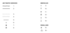
Symbol 16 in the attachment is a(n) (lightship).

Symbol 5 in the attachment is a(n) (…).

Symbol 5 in the attachment is a(n) (advisory airspace).

Symbol 1 in the attachment is a(n) (…).

Symbol 1 in the attachment is a(n) (Flight Information Region (FIR) ).

Navaid 6 in the attachment is a(n) (…)

Navaid 6 in the attachment is a(n) (TACAN)

On a Mercator chart, the scale (increases/decreases) with increasing distance from the equator.
On a Mercator chart, the scale (increases) with increasing distance from the equator.
Navaid 2 in the attachment is a(n) (…)

Navaid 2 in the attachment is a(n) (DME)

On a Lambert conformal conic chart, great circles that are not meridians are curves concave to the (…).
On a Lambert conformal conic chart, great circles that are not meridians are curves concave to the (parallel of origin).
Symbol 14 in the attachment is a(n) (…).

Symbol 14 in the attachment is a(n) (lighted exeptionally high obstacle).

Navaid 4 in the attachment is a(n) (…)

Navaid 4 in the attachment is a(n) (NDB)

Symbol 2 in the attachment is a(n) (…).

Symbol 2 in the attachment is a(n) (Airway (AWY) or Control Area (CTA or Controlled Route).

State how to calculate the convergency factor
CF = opening angle / 360°
Opening angle in attachment = 270°
- CF = sin(Po) -

Symbol 13 in the attachment is a(n) (…).

Symbol 13 in the attachment is a(n) (exeptionally high obstacle).

Symbol 12 in the attachment is a(n) (…).

Symbol 12 in the attachment is a(n) (lighted group obstacles).

Symbol 11 in the attachment is a(n) (…).

Symbol 11 in the attachment is a(n) (group obstacles).

